Lake Chapala - Extrapolated Lake Levels For 2019 Rainy Season
+8
NoVaDamer
slainte39
SunshineyDay
gringal
SunFan
CanuckBob
cypress
Cincy
12 posters
Page 2 of 2
Page 2 of 2 •  1, 2
1, 2
 Re: Lake Chapala - Extrapolated Lake Levels For 2019 Rainy Season
You have that one right : Many of the front lake properties belong to well off tapatios. it will be interesting to see what their position will be. Hopefully they will not want to be flooded and we will see if they use their influence or not. We are not on the lake but we are not that far from it so I am very interested in the subject. 
brigitte- Share Holder

- Posts : 4315
Join date : 2011-12-02
 Re: Lake Chapala - Extrapolated Lake Levels For 2019 Rainy Season
The lake levels since 1900...
https://www.ceajalisco.gob.mx/contenido/chapala/chapala/niveles.html
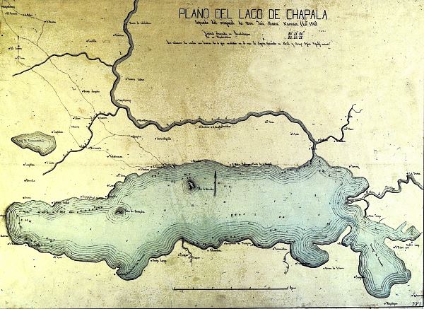
It's been higher. There are some older maps somewhere that show that the lake used to cover Jocotepic and around the mountain (the one with the Joco bypass) to where the cuota now is.
https://www.ceajalisco.gob.mx/contenido/chapala/chapala/niveles.html
It's been higher. There are some older maps somewhere that show that the lake used to cover Jocotepic and around the mountain (the one with the Joco bypass) to where the cuota now is.

ferret- Share Holder

- Posts : 10234
Join date : 2010-05-23
 Re: Lake Chapala - Extrapolated Lake Levels For 2019 Rainy Season
No doubt about it.. Jocotepec was around in the 1800 though because I remember translating some pages of a diairy written by an Italian and the man was describing Jocotepec as an unterresting place where the only nice thing was the niece of the padre.. so there was a town there
brigitte- Share Holder

- Posts : 4315
Join date : 2011-12-02
 Re: Lake Chapala - Extrapolated Lake Levels For 2019 Rainy Season
1524 Joco is old. Municipality in 1832.
La conquista la hizo pacíficamente Alonso de Ávalos en 1524, siendo los fundadores de Xolotepec los naturales, ya bautizados, Graciano Concepción, Santiago Jacobo, Jorge Simeón, Luis Cupertino, Salvador Hesperito, Pedro Tadeo, Lorenzo Antonio, Lorenzo Sebastián, Bartolo Jacobo, Juan de los Reyes, Andrés Joseph, Pablo Roque y familias. Se desconoce el decreto que lo erigiera en municipio, aunque el del 12 de abril lo menciona como municipalidad. En 1825 tenía Ayuntamiento, y el 13 de marzo de 1832 adquiere el título de Villa.
La conquista la hizo pacíficamente Alonso de Ávalos en 1524, siendo los fundadores de Xolotepec los naturales, ya bautizados, Graciano Concepción, Santiago Jacobo, Jorge Simeón, Luis Cupertino, Salvador Hesperito, Pedro Tadeo, Lorenzo Antonio, Lorenzo Sebastián, Bartolo Jacobo, Juan de los Reyes, Andrés Joseph, Pablo Roque y familias. Se desconoce el decreto que lo erigiera en municipio, aunque el del 12 de abril lo menciona como municipalidad. En 1825 tenía Ayuntamiento, y el 13 de marzo de 1832 adquiere el título de Villa.

Trailrunner- Share Holder

- Posts : 8007
Join date : 2011-04-18
 Re: Lake Chapala - Extrapolated Lake Levels For 2019 Rainy Season
ferret wrote:The lake levels since 1900...
https://www.ceajalisco.gob.mx/contenido/chapala/chapala/niveles.html
It's been higher. There are some older maps somewhere that show that the lake used to cover Jocotepic and around the mountain (the one with the Joco bypass) to where the cuota now is.
Just check out when Jocotepec was founded…..must have been some really old maps.
Like cave man drawings on a wall somewhere…..

slainte39- Share Holder

- Posts : 9348
Join date : 2010-07-22
 Re: Lake Chapala - Extrapolated Lake Levels For 2019 Rainy Season
Would you like it better if I said that the lake used to cover WHERE JOCOTEPEC NOW IS? Laguna Sayula was also probably part of it.
Look at this map from 1840 and you will see another section of the lake that is no longer there...

Here's a current one...

My point is that it will cross the lowest areas first if it continues to rise.
Look at this map from 1840 and you will see another section of the lake that is no longer there...

Here's a current one...

My point is that it will cross the lowest areas first if it continues to rise.

ferret- Share Holder

- Posts : 10234
Join date : 2010-05-23
 Re: Lake Chapala - Extrapolated Lake Levels For 2019 Rainy Season
You might be right at some ancient prehistoric time, I just questioned the map part as that is a more historic endeavor, and that pueblo has been there a long time.
45 years ago the lake was right up to the highway and bridge over the Lerma at La Barca, Jalisco and Las Briseñas, Michoacan , but not into Jocotepec.
slainte39- Share Holder

- Posts : 9348
Join date : 2010-07-22
 Re: Lake Chapala - Extrapolated Lake Levels For 2019 Rainy Season
That extra bit at the eastern end could have been very shallow swamp that was reclaimed with fill at some point. The rest looks pretty much the same. Ajijic has been here since 1534 (???) so it couldn't have been much higher here in the 1800's. The kitchen part of my house (which was probably the original structure) is built with adobe and my construction guy said it could be hundreds of years old as they haven't used adobe in quite some time.
_________________
Vacation Rentals
https://casadecomo.mx/
 Re: Lake Chapala - Extrapolated Lake Levels For 2019 Rainy Season
I've wondered why my ancient casa was built at considerable elevation from the street....but the answer is becoming increasingly clear.


gringal- Share Holder

- Posts : 11955
Join date : 2010-04-09
Location : Lake Chapala (from CA)
Humor : occasionally
 Re: Lake Chapala - Extrapolated Lake Levels For 2019 Rainy Season
There was a land developer involved at some point in the early 1900's. He built a beautiful hacienda home, now almost destroyed, and through a series of dams, etc., fundamentally changed the size and shape of the Lake. This is all on John Pint's website, url is something about Saudi caves.

CHILLIN- Share Holder

- Posts : 1943
Join date : 2011-08-10
 Re: Lake Chapala - Extrapolated Lake Levels For 2019 Rainy Season
gringal wrote:I've wondered why my ancient casa was built at considerable elevation from the street....but the answer is becoming increasingly clear.

Or the answer may becoming increasingly dark. We all know what flows better down hill!

CHILLIN- Share Holder

- Posts : 1943
Join date : 2011-08-10
 Re: Lake Chapala - Extrapolated Lake Levels For 2019 Rainy Season
CanuckBob wrote:That extra bit at the eastern end could have been very shallow swamp that was reclaimed with fill at some point. The rest looks pretty much the same. Ajijic has been here since 1534 (???) so it couldn't have been much higher here in the 1800's. The kitchen part of my house (which was probably the original structure) is built with adobe and my construction guy said it could be hundreds of years old as they haven't used adobe in quite some time.
I was told years ago that the oldest structures in Ajijic were on 16 de septiembre on the block where you are and a block or two in each direction from your house
slainte39- Share Holder

- Posts : 9348
Join date : 2010-07-22
 Re: Lake Chapala - Extrapolated Lake Levels For 2019 Rainy Season
And I've been told the original ayuntamiento was that old weathered adobe building down at the bottom of the tianguis.

Trailrunner- Share Holder

- Posts : 8007
Join date : 2011-04-18
 Re: Lake Chapala - Extrapolated Lake Levels For 2019 Rainy Season
If I'm reading the Lake Level chart correctly we're still 4 1/2 feet above the lake level at this time last year. Should be an interesting summer and fall.
SunFan
SunFan

SunFan- Share Holder

- Posts : 1308
Join date : 2011-09-11
Age : 76
Location : San Antonio Tlayacapan - Upper Chula Vista
Humor : None....no I'm joking.
 Re: Lake Chapala - Extrapolated Lake Levels For 2019 Rainy Season
I imagine a lot of this water will make its way to the Lerma river and then to us. They nay have to open the dams even earlier than July 1st.
https://mexiconewsdaily.com/news/leon-records-wettest-day-since-1961/?utm_source=Mexico+News+Today&utm_campaign=331e1661a4-MNT+june07-2019&utm_medium=email&utm_term=0_f1536a3787-331e1661a4-349534941
https://mexiconewsdaily.com/news/leon-records-wettest-day-since-1961/?utm_source=Mexico+News+Today&utm_campaign=331e1661a4-MNT+june07-2019&utm_medium=email&utm_term=0_f1536a3787-331e1661a4-349534941
_________________
Vacation Rentals
https://casadecomo.mx/
Page 2 of 2 •  1, 2
1, 2
 Similar topics
» Lake Chapala - Extrapolated Lake Levels For 2019 Rainy Season - 10 Jun
» Rainy Season 2019
» #367 2019.02.10 Yann Kostic & Tom Zachystal, Why All the Volatility and What This Means for Investors. Ajijic Open Circle, Lake Chapala
» #369 2019.02.24 Phil Rylett, Shot In The Dark The Intriguing Story of a Vaccination Program. Ajijic Open Circle, Lake Chapala
» #365 2019.01.13 Roy Quiriconi, Self Defense for Seniors. Ajijic Open Circle, Lake Chapala
Page 2 of 2
Permissions in this forum:
You cannot reply to topics in this forum|
|
|


